
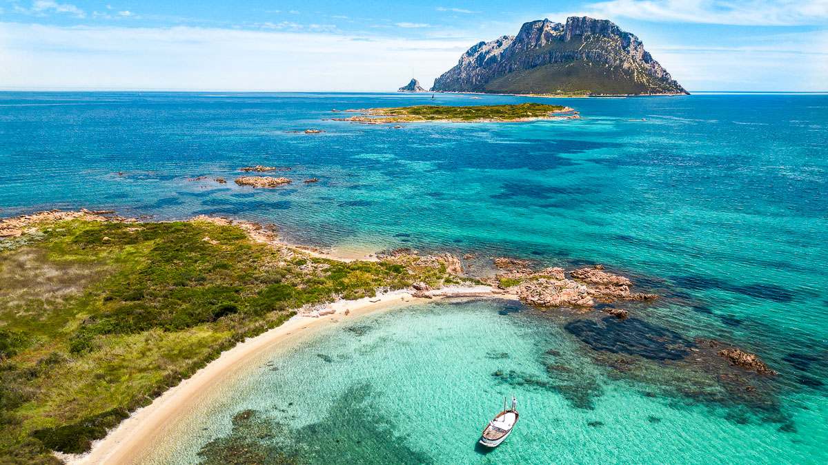
Best beaches in Tavolara, Molara and nearby islands
The best beaches of Tavolara and its surrounding islands — such as the famous Molara Pools, Isola dei Cavalli, and Isola Piana — offer something truly different from other coastal beaches. They face the open sea, farther from the mainland, where nature remains more authentic, untouched, and wild.
Because these beaches are located in less accessible areas, they are often quieter, with fewer visitors and incredibly clear water, rich in marine life and fish.
Many of these hidden coves can be reached only by boat, which is exactly what makes them so special. Reaching them means discovering secluded spots, unique scenery, and perspectives that cannot be seen from the Sardinian coast — especially those breathtaking views that can only be experienced while navigating Tavolara on a boat tour.
Table of Contents
The islands of Tavolara – Punta Coda Cavallo Marine Protected Area
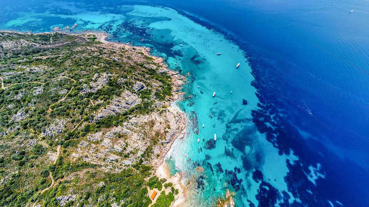
Many of the best beaches in Tavolara and Molara archipelago are located on the islands within the Tavolara – Punta Coda Cavallo Marine Protected Area. This protected archipelago includes numerous islands of different sizes: some are large and clearly visible even from the mainland thanks to their elevation, while others are small and more discreet — just a few dozen meters wide — yet capable of hiding secluded coves, crystal-clear beaches, and fascinating sea caves.
These islands preserve some of the most authentic and unspoiled coastal environments in Sardinia, accessible mainly by sea and ideal for discovering hidden beaches and unique natural scenery. Below are the main islands of the archipelago:
- Tavolara is the most famous island: impressive and unmistakable, with its towering limestone cliffs and beautiful beaches at the foot of the mountain.
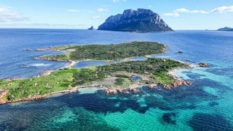
- Molara is wilder and greener, surrounded by secluded coves and crystal-clear waters, perfect for swimming and snorkeling.
- Molarotto is tiny and rocky, a true natural sanctuary for marine wildlife, where navigation and access are restricted to protect its fragile ecosystem.
- Isola Piana is a low and flat stretch of land located along the route between Porto San Paolo and Tavolara.
- Isola dei Cavalli is a small island featuring a beautiful white sandy bay just a few hundred meters from the mainland.
- In addition, a series of smaller islets and large rocks are scattered throughout the area, often forming sheltered inlets, hidden coves, and some of the most scenic and unspoiled spots of the Tavolara archipelago.
How to reach the islands
The islands of Tavolara and Molara are not connected to Sardinia by roads or bridges, so the only way to reach them is by crossing the sea. The easiest option is to depart from the area of Porto San Paolo, choosing between several available solutions.
There are ferries operating the Porto San Paolo – Tavolara route, ideal for those who want to reach the island directly without complications. However, they do not allow you to explore the other islands or discover the quieter, less crowded coves. Another option is to rent a dinghy, but in this case you must navigate independently. If you are not familiar with the area, distances, seabed, and wind conditions, it can be less comfortable and more demanding than expected.
The best way to experience these islands in total relaxation is often a guided boat tour, which allows you to reach hidden coves and enjoy the journey with swimming and snorkeling stops. With an experienced local skipper on board — someone who knows the area intimately — you can fully appreciate the history, unique features, and rich marine biodiversity of the Tavolara archipelago.
Rules and guidelines for swimming in the Tavolara Marine Protected Area
Respect the zoning regulations (Zones A, B, and C)
Do not touch or collect anything
Avoid to:
- Touching fish, starfish, or other marine organisms
- Collecting sand, shells, or natural “souvenirs
- Avoid standing on the seabed or on seagrass meadows
These actions may seem harmless, but they can damage a very fragile and protected ecosystem.
Do not feed the fish
feeding marine life can change their natural habits, make them dependent on humans, and negatively affect the fragile balance of the Marine Protected Area.
Be careful where you step
In shallow water, avoid walking on rocky seabeds or seagrass meadows: even small actions can cause damage.
No spearfishing (or invasive activities)
No loud music
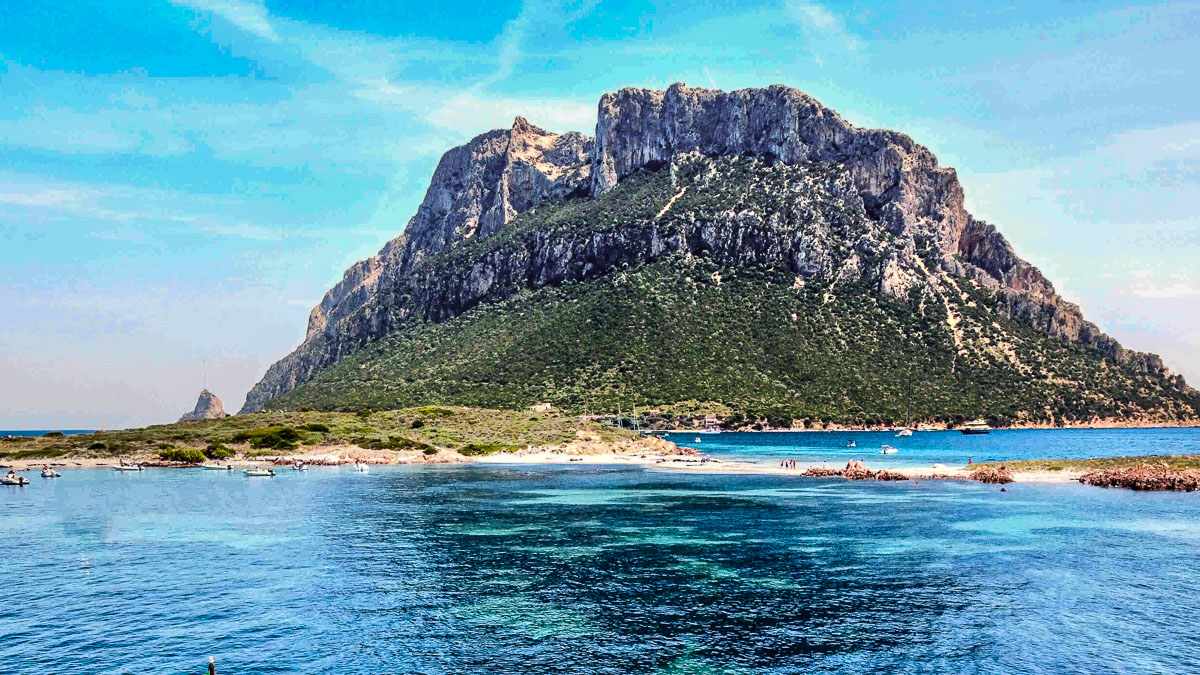
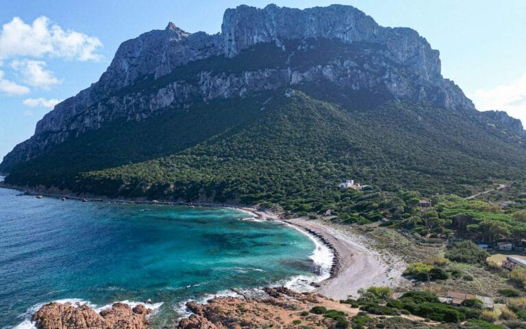
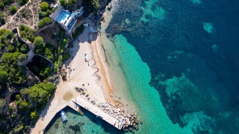
Tavolara Island
Spalmatore di Terra
The beach and the sea
The beach is about 1 km long. It begins with pebbles mixed with sand near the piers and gradually becomes sandier as you walk west. A distinctive feature is the dunes just behind the beach. The seabed is sandy, with Posidonia seagrass meadows alternating with areas of white sand. The water entry is gentle and shallow.
Recommended for...
Tavolara is accessible to everyone, but outside the restaurant areas, moving around requires walking along trails or the beach. There are no proper roads on the island.
Services
At Spalmatore di Terra, there are restaurants, perfect for a sea-view lunch break, and beach bars for a relaxing pause. The pier allows easy and safe disembarkation, but there are no rental services or shops. Public restrooms (or possibly private but available to visitors) are located behind the Da Tonino Re di Tavolara restaurant.
About halfway along the beach, there is a beach concession with sun umbrellas and loungers.
IMPORTANT: there are no trash bins available.
Shelter from the wind
Spalmatore di Terra is sheltered from winds coming from the Mistral, Tramontane, and Ponente (west). Winds from the southern quadrant, however, can bring waves.
How to get there
Once you disembark at one of Tavolara’s piers, the entire beach to the left is known as Spalmatore di Terra.
Watch map
More generally, the island can be reached from the port of Porto San Paolo by scheduled ferry or by boat tour. A full-day boat tour allows you to enjoy the island from a privileged perspective, as well as visit cliffs, caves, and other points of interest.
Interesting facts
Tavolara is considered the smallest kingdom in the world. Its “royal family,” the Bertoleoni family, has lived permanently on the island since the 1800s and even received official royal recognition from the Kingdom of Sardinia.
Over the centuries, the island has had several names. The oldest recorded dates back to the 2nd century AD, when it was called Hermaea (“the dwelling of Hermes”), in honor of the Greek god, son of Zeus.
When viewed from the sea, the island can take on different shapes: from a giant whale resting in the water to the back of a dinosaur or a reclining human figure. Because it is long and narrow, its appearance changes depending on the viewing angle and distance.
For over 30 years, Tavolara has hosted a film festival, the Tavolara Film Festival, held during the third weekend of July.
Il Passetto
Il Passetto is a narrow strip of sand, only a few meters wide, which can partially disappear depending on the tide. Walkable on foot, it connects the main part of Tavolara Island to the small islet located to the southeast.
This unique place is especially striking thanks to the meeting of two different seas and the fossil beach on the southern side. An unusual environment that offers moments of genuine wonder. A must-see when visiting Tavolara.
The beach and the sea
The beach is very small and has limited space available. It is more suitable for a walk than for staying for long periods.
The northern side faces the Tavolara isthmus, forming a small bay sheltered from waves generated by southern winds. It is sandy, with occasional deposits of Posidonia seagrass brought in by the tides. The southern side, on the other hand, opens onto a fossil beach that is now more similar to rock, leading into clear, light-blue waters that are excellent for snorkeling.
Recomended for...
The beach itself is suitable for everyone, but reaching it requires a 15–20 minute walk, which can be challenging during the summer.
Services
There are no services of any kind directly on this beach. However, the facilities at Spalmatore di Terra can be reached with the walk mentioned above.
Shelter from the wind
As mentioned earlier, the area is not very sheltered from the wind. However, swimming on the northern side protects you from waves coming from the opposite side, and vice versa.
How to get there
From the piers, Il Passetto is about 1.2–1.5 km away, and there are two ways to reach it: walking along the beach across the entire Spalmatore di Terra and then crossing the small hill that separates the two beaches, or taking the Prolago trail (the easier option), which starts near the piers behind the restaurants and leads to the western end of the island.
Interesting facts
Il Passetto, called u Passettu in Sardinian, means “the small passage.”
During winter storms, sea currents cover the strip of sand with Posidonia seagrass, which is later carried back into the sea by the wind once it has dried.
Il Passetto is one of the most photographed places in Tavolara.
Cala Tramontana
This is the north-facing cove of Coda di Terra, formed by pebbles and crushed limestone (partly quarried between the 18th and 19th centuries to produce lime) and smoothed by the sea. Here, the presence of the towering mountain massif above is truly impressive; in fact, many international visitors choose this location to celebrate their wedding.
It is the only true shelter from southern winds and is now also used as a unique and scenic wedding venue.
The beach and the sea
The cove is wide and deep, with only a small amount of sand set back from the shoreline. Rounded pebbles, carried by storms from the north and northeast, are the dominant feature here. Entering the water is not easy, and the seabed is rocky, but the water is exceptionally clear.
Recommended for...
Cala Tramontana is not suitable for everyone due to the difficulty of entering the water, but if the goal is to spend time on the beach, it also offers enjoyment for children looking for driftwood brought in by the sea. In addition, more adventurous visitors can explore further east, where the beach ends and the coastline continues among rocks and small inlets.
Services
No services are available directly at the cove, but restaurants and beach bars are located about 300 meters away.
Shelter from the wind
Well sheltered from southern winds, this cove becomes a popular spot when the Scirocco blows strongly.
How to get there
Reaching Cala Tramontana is quick, but the path is not well marked.
Walk past the restaurants and look for the trail that crosses Coda di Terra, which is only about 300 meters wide at this point.
The distance is so short that you can easily find your way by sight.
Interesting facts
The name Cala Tramontana comes from the bay’s northern exposure.
In 1562, a Turkish ship was wrecked in this bay. The residents of Porto San Paolo quickly reached the shipwreck survivors who had landed on Tavolara, seeking revenge for the many raids carried out by pirates during that period. They killed all the sailors and freed 30 Christian slaves.
In this part of the island, especially during winter, it is common to find objects and driftwood brought ashore by storms.
Navy Pier Beach
On the eastern side of Coda di Terra, beyond the Military Navy piers, there is a small beach with no official name, often referred to simply as the Pier Beach. It is rarely crowded and has a romantic atmosphere.
This spot feels different from the more well-known beaches: more intimate, with mixed seabeds and a secluded atmosphere. It is the last stretch of coast before the trails that lead to the summit of the island, and it lies next to the historic lime kilns.
The beach and the sea
The beach is sandy, with a gentle entry into the water and mixed seabeds.
Recommended for...
This may be the only beach with a paved access from the main piers, except for a few meters of pebbles just after disembarking and turning right.
The beach is easy to reach and located close to the restaurants for any needs.
Services
No services are available directly at the beach, but as mentioned above, the restaurants are only a very short distance away.
Shelter from the wind
Here, the Scirocco wind is almost unnoticeable, and even the Tramontane rarely reaches this area.
How to get there
Very easy to reach. After disembarking at the main piers (the Military Navy pier is strictly reserved and rarely used), walk a few dozen meters along the coast, keeping the sea on your right. The beach is located just past the military pier.
Interesting facts
The Military Navy pier is used only by their vessels in case of strong northern winds, when docking at Punta Timone becomes difficult.
The house overlooking the small beach is the home of Tonino Bertoleoni, the King of Tavolara.
Molara Island
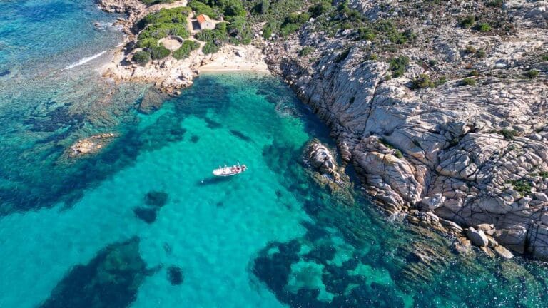
Molara is located just a few miles from the coast and, like Tavolara, can only be reached by sea. The island is entirely private (it belongs to the Tamponi family), so it is possible to disembark from the boat and swim to the beach, but landing or exploring inland is not allowed without explicit permission. The seabed is sandy and crystal clear, and swimming is typically done directly from the boat. Snorkeling here is easy and suitable even for beginners.
The original name of Molara is Salzài (derived from “alza,” meaning wasp), and it is one of the most famous and visited places in the entire Marine Protected Area. It is said that Pope Pontian was exiled here in 235 AD (a small church, now in ruins, is dedicated to him), and that during the Middle Ages a castle (Castello di Molara) was built as a military outpost.
Le Piscine di Molara
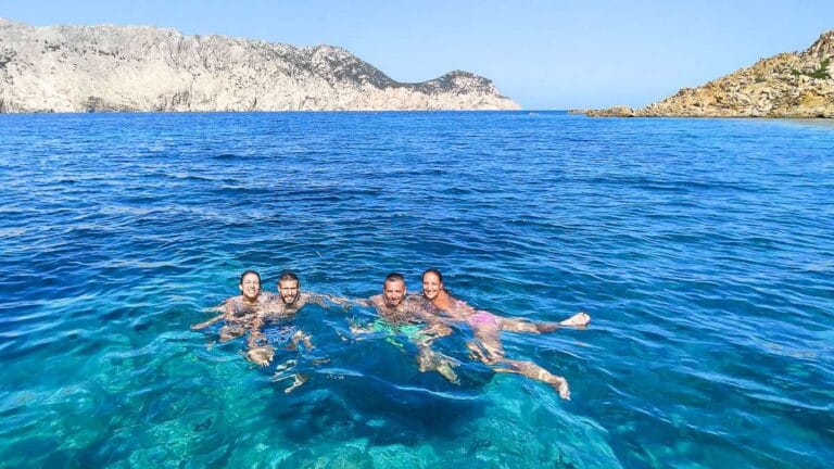
The Molara Pools are perfect for those who enjoy experiencing the sea from the boat and snorkeling among the fish.
It is an ideal stop for couples, families, and groups of friends, as well as for anyone who wants to alternate relaxing swims with scenic moments during navigation. It is also one of the best spots for sunset aperitifs by boat, when most boats have returned to the harbor and the atmosphere becomes more peaceful and intimate.
The beach and the sea
The Molara Pools are actually a group of small bays, two of which have real sandy beaches that can be easily reached by swimming.
Access to the water is always from the boat, with exceptionally clear and transparent seabeds, often populated by saddled seabream and damselfish waiting for food. The average water depth ranges from 4 to 8 meters.
Recommended for...
Boat trips to the Molara Pools with Sole Sale Sardinia are suitable for everyone, thanks to slow, comfortable, and safe boats equipped with spacious sunbathing areas and shaded spaces.
Services
There are no services of any kind on the island, but with the right boat trip you will have everything you need to enjoy an unforgettable experience. In addition, within the Marine Protected Area during the high season, two boats provide bar service with drinks, ice cream, and crêpes.
Shelter from the wind
Depending on the specific area of the Molara Pools where you stop, you may be sheltered from different winds, ranging from Scirocco (southeast) to Tramontane (north).
However, winds coming from the west and northwest can affect the entire area.
How to get there
As mentioned earlier, the Molara Pools can only be reached by boat through guided tours and different types of vessels. We always recommend carefully choosing among the available options.
If you would like to see where the Molara Pools are located on the map, click here.
Interesting facts
They are called “pools” because the water is often calm even when the Scirocco wind is very strong, with incredible colors ranging from turquoise to emerald green, like natural swimming pools.
These intense shades come from the combination of a light-colored seabed, fine sand and rocks, together with sunlight: on clear days, the colors can appear almost unreal.
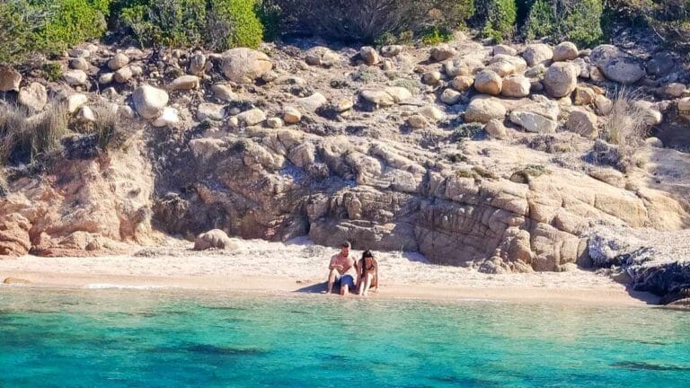
Cala Spagnola
This cove, located next to the Molara Pools on the western side, is very distinctive and wild, with a beach that looks like a movie set, surrounded by rocks and not easily accessible except by boat. It has limited space available and is even more sheltered from the Scirocco wind than the nearby Molara Pools. It is an excellent choice for a relaxing break and, why not, a peaceful nap.
The beach and the sea
The beach is not very large, sandy, and framed by large, scenic rocks. The entry into the water from the shore slopes gently, and the seabed is mixed, with sand, patches of Posidonia seagrass, and rocks. The water is so clear that the seabed can be easily seen even from the boat.
Recommended for...
Here as well, arriving by boat depends on the type of excursion chosen, but reaching the beach is easy, requiring only a short swim of a few dozen meters.
Services
As mentioned earlier, there are no services of any kind on Molara. However, there is no need to worry, as you will find everything you need on board the boat.
Shelter from the wind
Very well sheltered from the Scirocco and, in general, from all winds coming from the south.
How to get there
Here as well, the only way to reach Cala Numeru Unu (as it was called by local fishermen) is by boat.
Interesting facts
On Molara, there are Cala Numeru Unu (also known as Cala Spagnola), Cala Numeru Duos, and Cala Numeru Tres. These coves have long been the subject of discussion due to the numbering order, which local fishermen would sometimes change. The version in which Cala Spagnola is considered Cala Numeru Unu is the most widely accepted.
At sunset, the pink hues of the sky blend with the reflections on the sea, creating extraordinary and unforgettable scenery.
Cala Chiesa
Moving further east and away from the usual tourist routes (rental dinghies do not reach this area), you will find Cala Chiesa, just before rounding the corner where the island turns from north to east.
This wild and secluded place takes its name from the small church built in memory of Pope Pontian.
The beach and the sea
There is no beach here, only a small inlet where seasonal streams flowing down Molara’s slopes reach the sea, carrying pebbles and natural debris.
The seabed is mostly rocky, with Posidonia seagrass meadows and only rare patches of sand. Excellent for snorkeling and for observing marine species that are different from those typically found in sandy underwater environments.
Recommended for...
Swimming from the boat is generally easy, but reaching the shore and landing by swimming can be more challenging than in other coves of Molara.
Services
As with the other coves of Molara, there are no services here, and even the floating bar boats do not reach this area.
Shelter from the wind
This cove is sheltered from the Scirocco and from winds up to the west, and in some parts of the bay even from the Mistral.
How to get there
This is one of the points farthest from the Sardinian mainland. In many areas, there is no mobile phone signal, but the scenery and tranquility more than reward the effort.
Interesting facts
A small village once developed around the Church of San Ponziano, probably the ancient settlement of Gurgurai. Nearby, on top of the hill, the Castle of Molara was built as a lookout point to guard the surrounding coasts.
On the island, it is still possible to see cows and goats living in the wild, left behind when the farm was abandoned in the 1970s.
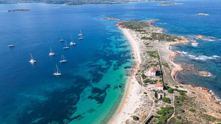
Isola dei Cavalli Island
Isola dei Cavalli takes its name from the semicircular shape of its bay, which resembles a horseshoe.
Isola dei Cavalli Beach
A place that, despite being very close to the coast, inspires a deep sense of tranquility thanks to its clear and shallow waters.
Sunset here is magical, offering beautiful colors, and the view of Tavolara is breathtaking when it turns pink in the light of the setting sun.
The beach and the sea
The beach is about fifty meters long and very narrow, with fine sand of a light yellow color, almost white. The water remains shallow for several meters, and the seabed is free of rocks.
Recommended for...
This beach is a true paradise. It is not uncommon to see mega yacht crews attempting, often unsuccessfully, to set up gazebos and loungers on the shore for their owners. It is a highly sought-after destination.
Services
The island is approximately 70 by 70 meters in size. There are no services of any kind.
Shelter from the wind
This beach is sheltered from the Mistral and Tramontane winds.
How to get there
The island is only a few hundred meters from the coast, but swimming there is not recommended due to boat traffic in the channel in front of it.
Interesting facts
It is easy to spot octopuses emerging from their dens among the rocks at the edges of the island, easily visible against the bright white sand.
During the summer, Canadair firefighting aircraft collect water from the sea behind the island to extinguish wildfires, performing spectacular low-altitude flights.
The Sardinian name is S’isula de sos Caddos.
Isola Piana
Isola Piana takes its name from the absence of elevations across its entire surface, which measures approximately 500 by 200 meters.
Spiaggia dell'isola Piana
Isola Piana lies next to Isola dei Cavalli, separated only by a narrow channel used by boats traveling from Porto Istana to the islands. They are almost like sister islands, with Isola Piana being the larger of the two.
Its bay is wider and more spacious than the previous one, yet equally beautiful, with very fine sand. In spring, the island turns yellow thanks to the blooming broom shrubs.
The beach and the sea
The beach is small and welcoming, with a gentle slope that allows visitors to lie comfortably in the shallow water. The seabed is sandy.
Recommended for...
This beach is perfect for both adults and children.
Services
There are no services of any kind on the island.
Shelter from the wind
Well sheltered from the Tramontane and Levante (east) winds. Partially sheltered from the Scirocco.
How to get there
Isola Piana can also be reached by kayak, as it is located about 1 km from the coast. Departing from Porto San Paolo, it is impossible to miss: it is the second island on the right when heading toward Tavolara.
Interesting facts
Seagulls love to nest on this island, and in spring it is common to see young birds practicing their first flights nearby.
Together with the bay of Tavolara, it is one of the few places offering complete shelter from the Mistral wind.
How to visit the beaches of the Tavolara archipelago islands
Tavolara and the nearby islands change their appearance every day: light, wind, and sea conditions transform colors and the possibilities for stopping along the coast. If you want to see the most beautiful coves at the best time, the best choice is to rely on those who navigate these waters every day.
Take a look at our boat tours or choose a private tour: we will take you to the most spectacular (and often less crowded) spots to experience this area at its best, by boat and beyond.
Written by:
